5.11 Acres for Sale in Beatty, Oregon
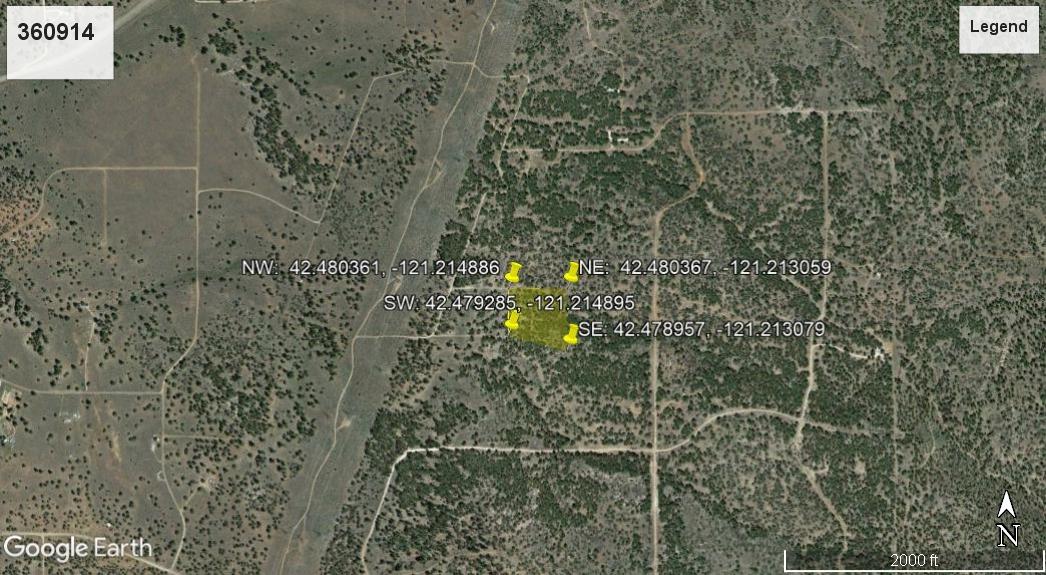
Parcel: 360914
Size: 5.11 acres
Address: Beatty, Klamath County, Oregon, United States, 97621
Location: 42.480361, -121.214886
Deed type: Warranty Deed
Road access: Dirt Road
Utilities: No utilities
Zoning: Residential
Taxes: 128.00
Legal: A parcel of land situated in the NE ¼ of Section 6, Township 36 South, Range 13 East of Willamette Meridian, Klamath County, Oregon, being more particularly described as follows: Commencing at a 1 ½ inch iron pipe with brass cap marking the Southeast corner of said Northeast quarter of Section 6, 384.84 feet to a ½ inch iron pin marking the point of beginning for this description; thence continuing North 00 degrees 45 minutes 25 seconds East along section line, 510.00 feet to a ½ inch iron pin, thence leaving said section line West 488.99 feet, thence South 369.27 feet to a ½ inch iron pin, the
SUBDIVISION: Undisclosed
STREET ADDRESS: N/A, Partin Dr, Beatty, OR 97621
STATE: OR
COUNTY: Klamath County, OR
ZIP: 97621
SIZE: 5.11 acres
LOT DIMENSIONS: 492 feet (Northern Leg) x 526 feet (Eastern Leg) x 508 feet (Southern Leg) x 403 feet (Western Leg)
APN: 360914
LEGAL DESCRIPTION: A parcel of land situated in the NE ¼ of Section 6, Township 36 South, Range 13 East of Willamette Meridian, Klamath County, Oregon, being more particularly described as follows: Commencing at a 1 ½ inch iron pipe with brass cap marking the Southeast corner of said Northeast quarter of Section 6, 384.84 feet to a ½ inch iron pin marking the point of beginning for this description; thence continuing North 00 degrees 45 minutes 25 seconds East along section line, 510.00 feet to a ½ inch iron pin, thence leaving said section line West 488.99 feet, thence South 369.27 feet to a ½ inch iron pin, thence South 76 degrees, 44 minutes 08 seconds East, 495.47 feet to the point of beginning.
GOOGLE MAPS LINK: https://goo.gl/maps/wwG2DZe8XkibdbWT7
LAT/LONG COORDINATES:
NW Corner: 42.480361, -121.214886
NE Corner: 42.480367, -121.213059
SW Corner: 42.479285, -121.214895
SE Corner: 42.478957, -121.213079
ELEVATION: 4,656 ft
ANNUAL TAXES: Approx. $128.00 per year
ZONING: (R-2) Rural Residential 2ac - No time limit to build. Site built, mobile homes & manufactured homes are okay. The building code that Klamath County uses allows houses as small as 300 sq. ft. RV’s are allowed for camping but not as a permanent residence. Camping is allowed for up to 21 days every 6 month period. Permits only required if staying for more than one week at a time. Tiny homes on trailer frames are registered by DMV as an RV so fall under the camping regulations. Call Klamath County Planning Division 541-883-5121 Option 4 for more info.
HOA/POA: No
IMPROVEMENTS: None
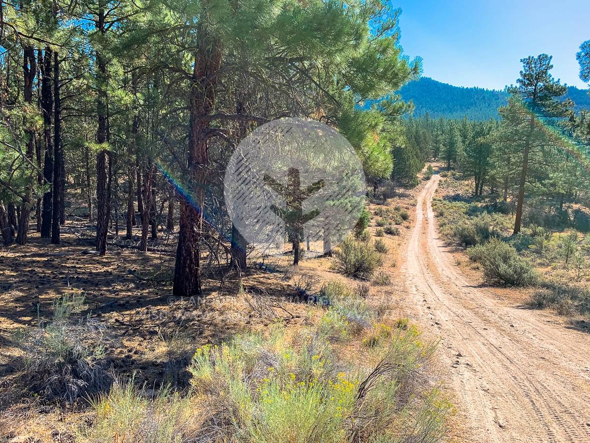
ACCESS: Roads are unimproved rough dirt roads. 4WD with ground clearance is recommended. Dirt road into property is not maintained off the main road in. There is a hill before you get to get to the property.
WATER: Would be a well, water haul and holding tank or other similar option
SEWER: Would be by Septic
UTILITIES: Transmission line is nearby but there was no power post near the property. Power could also be by solar, wind or generator, Phone by cellular, satellite TV/Internet/Phone